Monday, February 4, 2008

Back to the coast


So we've made it to Riverton on the south coast of the South Island, we can see the hill of Bluff. Its only a few days away, we'll be finishing there on the 7th of February. It's hard to believe that after all our planning and months walking that the end is literally in sight.

We started off this section going through the Takitimu Ranges. I nicknamed that day 'Angry Foliage Day'. It brought back memories of struggling through the North Island bush, with every plant trying to entangle you. There was a vine similar to Bush Lawyer that hung down above us, the tiny hooks digging into our clothing and skin and ensnaring our packs. Lining the track at shin height was a constant trail of a benign looking grass which actually had nasty hooks at the end. The worst part was that we could walk past some of it and be fine, other times it hooked your leg so it felt as though a knife was being pressed into our skin. Not the best feeling.

We headed through five farming stations over a couple of days. The biggest by far was Mt Linton Station. We started at the back end of the station, walking down the 4WD tracks to eventually get to the main road. It took us most of the day to walk through it, right from the start I decided that this was one of my favourite stations so far. Everything looked well maintained with nice fences, good roads, and a bustle of activity. Often we head through farmland and don't see anyone, just a bunch of stock hanging out. When we got to the road end we found out that it was actually one of New Zealand's biggest stations and had over 100 000 head of stock. We knew it was big, but had no idea it was that big. Thank you to all the station owners who have let us walk through their land, we really appreciate the access. It gives us the opportunity to stay off the main roads.

Dennis celebrated his 27th birthday on the 2nd of February. The gift offering was a little meagre, it can be tough when his birthday falls on the 5th day of a 6 day section, there's only so much extra you can carry. We ended up pushing on further than intended that day and made it to Riverton so we could at least go out for dinner.

Throughout our hike we have come across the most generous people who have been really interested in our trip and willing to help us out. It has made the trip for us, we have loved meeting a wide range of people from all over the country. This section was no exception. We stopped in at one house to get water and were offered an orange drink - on a hot day there's nothing better than a cold glass of anything but water, its nice to have a change. We also met the family from Blackdale Stud as they were herding their sheep down the road. We ended up going back to their house for a chat, some cake and were given some fresh eggs. These experiences really brighten our days.

We've come across some amazing local hospitality here in Riverton too. We're staying at the Riverton Lodge, which at $10 a night is the best deal around. We met some of the locals at the pub attached to the lodge last night. Since then we've been given fresh crayfish, a driving tour around Riverton, and are heading out for a home cooked meal tonight. We have been blown away by everyone's generosity. Thank you so much, we won't forget you.

Alice

Photos:
Dennis and his gravity defying socks
The landscape around Mt Linton Station
Sunset at our campsite
The sheep from Blackdale Stud heading down the road
Riverton from the Aparima River
Monday, January 28, 2008

Leaving the mountains


Rain, rain go away. It finally did, but it took a while. It wasn't until after 2pm. We started off in Queenstown where we had to hitchhike back out to where we left off. We hitchhike to get into towns to resupply with food, never in a positive direction. After we get food and a break, its back out to where we left off, so we don't miss a single step between Cape Reinga and Bluff. Thank you to all the kind people who have given us rides, and to those people who offer them. We always get offered rides when we can't take them, but when we do need them we're often left stranded on the side of the road, watching cars wizz by at 100+km an hour. When its raining, it can be hard to turn down rides. Especially when a large, dry, warm bus pulls over and offers you one. The driver's comment was: "I thought you were one of the crazy ones who didn't get the shuttle to the start of the trail. But you're not. You're even crazier."

We eventually got to the trailhead of the Greenstone Track where we slept in the shelter. We only did a small portion of the Greenstone, a very well maintained track that had small footbridges over every tiny dip in the trail. From there we made our way to the Mavora Walkway, quite the opposite from the Greenstone. I wouldn't have turned down a few of those small footbridges as we picked our way through the boggy marsh.

We found ourselves back in farm country, I even saw my first real life cowboy. He was out mustering cattle in the Mararoa River Valley, moving them into the Greenstone River Valley over 5 days. Cattle must walk pretty slow because it was only 30km away.

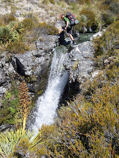
One highlight was a waterfall stream crossing. The easiest place to cross was at the top of a 5m high waterfall. The water cascaded past the rocks we jumped between and dropped into an emerald green pool.

We've had plenty of time on this trip to observe crazy stock antics. It seems sheep tend to run away when they see us, while cows run towards us. We have had times walking along the road when there are over 100 cows trailing us in an adjacent paddock. Sheep on the other hand can be painful to watch. We can be 100m away and half the time they see us then proceed to barrel right into a fence. Two things can happen, it hits the fence and rebounds off, or it manages to get half its body through. With each ensuing step we take the sheep squirms and bucks until either it gets through or gets stuck. I walk over to the stuck ones, my presence is usually enough to get them to try harder to get through. We saw a mother and a lamb in a field, they were 50ft away and looked totally calm. Then all of a sudden they bolted towards the fence, I'm usually shouting "No! No!" at this point. They smash into it, Mom gets halfway through, the lamb rebounds, the mother squirms through and keeps running. Doesn't even look back. No more lamb.

We finished off this section with some on the fly route changing. We saw some DOC workers along the way and enquired about another small section that would keep us off the roads. We headed down the Oreti River Valley and spent the night at the Lincoln/Patterson Bivouac, a pint size, orange box in the trees with 2 bunks. On popular tracks some of the huts have flush toilets but they do not have as much character as these small, rarely used ones.

Next update will be from the south coast of the South Island. It will have been over 2 months since we've seen the sea, almost to Bluff.

Dennis

Photos:
Dennis at the waterfall crossing
Alice walking through tall tussock
Carey's hut on the shores of North Mavora Lake
Lincoln/Patterson Bivouac

Monday, January 21, 2008


We changed up our route again between Wanaka and Queenstown. It meant
we had to head north a bit, which goes against our final aim but it
was well worth it. We ended up heading through Mt Aspiring National
Park which was full of jagged mountains and glaciers.

We meet a lot of people on our journey who are impressed with what we
are doing, the most common response being either "you're crazy", or
"you're keen". On our way up the Matukituki River Valley we met a
family who definitely won our respect. The couple from Seattle, who we
totally forgot to even ask their names, were out hiking with their two
young sons. One was 8 months, the other I think was 2 years. The
mother was carrying the 2 year old in a backpack with some gear, the
father had the hugest pack I've ever seen and the baby on his front.
That's dedication to keeping up the outdoor lifestyle when you also
have a young family. We were impressed and inspired (not that we're
planning on popping out kids any time soon.)

We headed up and camped just below the treeline on the way towards
Cascade Saddle. We heard that it was meant to rain overnight but clear
around midday. We planned on having a sleep in to let the weather
clear and I went to bed thinking 'alright rain, bring it on, get the
wet out of your system by tomorrow'. By that I did not mean for it to
start raining inside the tent. It deluged from around 7pm to 1pm the
next day. We tested our single wall tent to the limit, and it didn't
do so well. Luckily we were on foam sleeping mats, otherwise we might
have drowned. We woke to water dripping on our sleeping bags, our
faces, all our stuff inside the tent, and pooling in the indents in
our sleeping pads like an ice cube tray. Life was pretty miserable at
that point. Our bodies were seizing up from too much time lying down,
it was pouring out, and we needed to pee. We debated what to do, it
was approaching 12, the weather didn't look like it was changing but
we couldn't handle much more time in our cramped, wet tent. Finally
around 1pm the rain abated, by this point we were already starting to
pack up inside the tent. By the time we got going at 2 and got above
the treeline the sky was a perfect blue, its crazy how it can change
down here.

The Cascade Saddle route was another that can with serious warnings:
Do not attempt this route in adverse weather, steep snow grass slopes
are treacherous when wet, etc. We didn't have any problems, in fact,
we were delighted to find an actual trail went the whole way so we
didn't have to walk right on the slippery snow grass and tussock. I
guess a lot of people do get caught out every year who aren't prepared
or do not have the common sense to deal with bad weather conditions.

We ended up having an amazing day. The Cascade Saddle is right next to
the Dart Glacier, the closest we've got to a glacier since living in
France a couple of years ago. It was impressively deep and there was a
stunning 1000m drop off on one side back down to the Matukituki River.
It was worth the wait in the rain and the steep climb to get to it.

We saw some Kea when we were up at the saddle. Kea are a big green
parrot native to NZ who are too smart for their own good and have an
attraction for shiny and expensive gear. They are known for ripping
rubber parts off cars and shredding unattended tents. This made us a
little nervous as they hung around while we were having lunch with all
our wet gear spread out around us. Other than having to keep a close
eye on them, they are magnificent birds. Especially in flight with the
orange underside of their wings flashing as they soar above.

We then finished our route down to Glenorchy down the Dart, then Rees
River Valleys. We saw more people on the Dart/Rees loop than we have
in a while. You can always tell which are the most used tracks because
the huts are in the best condition. We feel some of these huts have
moved beyond the 'backcountry' label, we stayed in the Dart Hut which
had 32 beds, a huge kitchen/seating area, big deck space and,
unbelievably, flush toilets! Definitely unexpected but necessary I
suppose when there are that many people coming through one area.

We're now in Queenstown which isn't officially on our route - we
hitched from Glenorchy down to here to resupply. Plus we were able to
stay in the Markham's place down here which has been pure luxury for
us. Beds with sheets and a real pillow instead of a rolled up fleece
and sleeping bag, a couch to hang out on, and a kitchen with pots and
pans that we don't have to share with 1000 others. We loved it. Thank
you so much.

Alice

Photos:
Impressive backpacking family
Alice and Dennis at Cascade Saddle
Alice looking over the 1000 M drop off
Dart Glacier
Inquisitive Kea

Sunday, January 13, 2008

RIP second pair of shoes


They were doomed from the start. Out of the box just five days before in Wellington I ripped a hole in the side in the Richmond Range. I was almost reduced to tears, $150, 5 days old. Al propped me back up, slapped some sense into me, and I was off hiking again. I wasn't about to give up on them that early, I can sew. I must've been a cobbler in a past life because I managed to keep the shoes alive until yesterday, when I put them into retirement.

Half a spool of thread, seven sewing needles, five thread patches, two duct tape patches, two cloth patches, a tube of glue and probably over 20 hours of my time into keeping them going.

It was said in one of the backcountry hut books in the 'main activity of this trip' column: "Wearing the tread off the soles of my shoes". We have been doing just that. Have I learned anything? Mesh shoes have no place in the rocky New Zealand terrain.

Thanks to Santa, who is apparently great friends with my parents, I was sent some brand new Montrail Hurricane XCRs, the same shoes I used for the entire North Island. I am very thankful for that and can assure you all I will be walking out of Wanaka with some shiny new shoes on and a big smile. I'll probably be tripping a lot, its been a while since I've had tread. I hate that.

Dennis

Running from the sandflies


It finally happened. We went to the DOC information centre in Twizel and we were able to talk to a knowledgeable staff member. Time after time, the people we are able to talk to at DOC are not the ones who are out on the trails, and we are generally not wanting to do the one hour tourist loop so we inevitable leave frustrated. But Richard McNamara at Twizel was great. We had reservations about the route we had come up with ourselves, we thought it went through a lot of private land. It did, so seemed too complicated to attempt it. We ended up with a much better route though that took us up river valleys and over ridges.

We walked past Lake Ruataniwha and Ohau to Freehold Creek. We ended up walking up the ridgeline in between Freehold and Parsons Creeks. It was another stunning day where we woke to clouds, but after about an hour of walking they broke apart and we were given amazing views over the lakes and glacier covered mountains. It was a steep climb, but well worth it.

The walk down the other side into Snowy Gorge River wasn't quite so fun. The barren ridgeline was replaced with waist high tussock, uneven ground and spiky tipped plants. We have actually just learned the name for our most hated plant. The Spaniard, or appropriately nicknamed Bayonet Plant, is the real name for what we had dubbed 'The Spiky Plant of Death', or SPOD for short. This one draws blood when you walk past it and Dennis had a particularly painful experience with it in the Nelson Lakes National Park when he slipped down a bank and ended up with 22 holes in his right hand and wrist when he landed in the plant. But we're pretty good at avoiding them now and the hut at the end made it all worth it.

From the Snowy Gorge River Valley we headed up the Ahuriri Valley and over into Dingle Burn Valley. This was another beautiful valley with jagged peaks, glaciers and cool gorges as we went down. Pity about the sandflies though. We haven't had to deal with the dreaded sandflies in quite a while, our two days in the Dingle Burn Valley sure made up for it though. Our first night at the Top Dingle Hut was bearable, we were dressed in socks, full length pants and long sleeved tops which kept them away, we just couldn't have our headlamps on after dark. Our second night at Bush Hut was another story. It was insanely hot in the hut but opening the door or window would've been suicide. We ate dinner sweltering in our long clothes, our wrists and hands getting attacked from every angle. Eventually we couldn't take it anymore and, for the first time, abandoned the hut for our tent. We were speed machines. That tent has never been put up so fast, we threw our gear and ourselves into it then went on a five minute killing spree to get all the flies that managed to get in. I didn't want to get out of the tent in the morning. I woke to the mesh screen completely covered in bugs, it sounded like rain because so many of them were flying into the side. Again, the tent was down in record time, I could hardly see Dennis when he was rolling it due to the swarm of bugs surrounding him. Sandflies are definitely the downfall of some of the most scenic spots down here.

We headed out of the valley to the shores of Lake Hawea, my favourite lake so far. We were following a really cool gravel road cut into the cliff which gave us amazing views of the surrounding mountains and deep water.

On this section we also finally did a 40km day. We've got close before with 39 and 38km days but we figured we had to cross the 40 threshold before the end of our trip. We'd started the morning walking down a river with endless crossing in freezing water so we needed a fast paced afternoon to make it. But hey, if we're going 40, we may as well make it a marathon. We ended the day with 42.4km behind us, and our bodies were holding up fine.

We're currently in Wanaka having a couple of rest days. We're thinking of moving here for the winter once the hike is done so we want some time to check it out. It seems strange to think about snow in this crazy heat but we like it here so far.

Alice

Photos:
Alice walking up the Freehold Creek ridge with Lake Ohau in the background
The view up Dingle Burn River to the start of the valley
Dennis doing the steep scramble down to Dingle Burn
Alice and Dingle Burn river gorges
Lake Hawea

Canals, canals, canals


There's something to be said for mountains, the feeling of achievement, amazing views and interesting trails. As for canals, well, maybe not. We had two days of walking along the flat Tekapo Canal between Lake Tekapo and Twizel. Al and I rochamboed to see who should write this one, I lost. I always throw scissors, why did I throw rock?

It wasn't all terrible, we had amazing views of Mt Cook for two straight days, and perfect weather. Absolutely no clouds, just sun. No trees either and no shade for that matter. Al and I did manage to get a bit of shade next to Lake Pukaki Information Center. We were cowered against the side of the building in the bushes. Not the prettiest sight but it was shade.

Dennis

Photos:
Tekapo Canal with Toitoi
Mt Cook from the canal
Mt Cook from Lake Pukaki

Thursday, January 3, 2008

Rivers to mountains 2


Photos:
Us at the top of Mt. Musgrave (2251 Meters), out highest South Island point.
Our New Years Campsite
The Two Thumb Range, looking back at Mt. Musgrave
Coal River

Rivers to mountains


Its amazing how fast an eight day section can go by, you start off with a heavy pack and slowly whittle your way through the food until you're back to a light pack. It can be challenging not to eat too much trail mix on the first days, leaving you with none for the last.

There's no shortage of variety in this section: flats, hills, tracks, roads, mountain tops, river valleys, rain, sun and even hail. We had it all. It started out with a bit of road walking and after a milkshake in Staveley, it was time to venture into Mt Somers Forest Park. I'm such a sucker for milkshakes, I figured it would be the last one for a while. Uphill, what's that? It's been a while since we've had to do any big climbs. I'm not sure what was against me, the legs or the brain but it was a bit of a difficult start. Maybe it was the weather, a bit of drizzle, followed by hail. That's enough to get you unmotivated.

Mt Somers Forest Park was an amazing place. It had all sorts of crazy rock formations. The Pinnacles Hut on our first night was in a great location, placed among the Pinnacle rocks, made me wish I'd brought my climbing shoes with me. Further on down the track there were water caves to explore. It was as if someone had a handful of enormous boulders and sprinkled them over a stream. There were all these voids and precariously balanced rocks with water running through them. It was an amazing spot to explore, nature's jungle gym.

Then it was back on the roads passing by Lake Clearwater to the mouth of the Potts River. This was the start of the big river crossing that has been in the back of our minds for quite some time. The Rangitata River drains the glaciers of the Southern Alps and runs south east to the coast. It was in the way and needed to be crossed. The river from the first channel to the last was five kilometers wide and quite braided. We counted the channels on the way across, the smallest being one meter wide, stretching up ones that were over ten meters wide. We crossed 48 channels. It didn't turn out to be as difficult as first though, most channels were knee deep with the final channel being waist deep with a bit of heavy current.

We headed up Forest Creek valley and up Neutral Creek to the Two Thumb Range. Our original plan had us following the Coal River out of the mountains. At this point I was feeling I needed a change from all the river walking and started looking for another route to explore. The landscape here is so barren and vast you can pick a ridge or valley and hike it. There are no trails but also no trees or vines to get yourself tangled up in, just tussock and wide open space. We decided we'd follow the mountain tops of the Two Thumb Range to the Richmond Range.

Our new plan looked as if it was going to be thwarted when we woke up to heavy mist. Al opened her tent door, looked out, said she couldn't see the stream we were camped next to, said maybe we should wait it out. I agreed, half asleep, without even looking, rolled over and went back to sleep. Around midday, when it hadn't improved, we started our climb for the ridge. When we reached it we left behind the clouds. Over the course of 50 meters the weather changed from no visibility to no clouds with perfect blue sky. This made our time on the mountain tops spectacular. We had incredible views of the Southern Alps. We reached our highest point in the South Island, Mt Musgrave at 2251 meters tall. We brought in the New Year at our highest campsite at 2075 meters, 360 degree views and a beautiful sunset. According to Al, all that was missing was a glass of wine. The clock struck 12, already in our sleeping bags we wished each other a happy new year, rolled over and fell asleep.

We are now in Lake Tekapo enjoying a sunny rest day, heading towards Twizel tomorrow.

Dennis

Pictures:
Pinnacle Rocks by the hut
Water Caves
Dennis crossing one of the 48 Rangitata River Channels
Neutral Creek Gorge
Coming up to the ridge line out of the clouds

Monday, December 24, 2007

Merry Christmas


We've just walked over 100km in three days, hit our 3 month anniversary of the start of the hike and our 2000km mark, so we're moving along.

We left Arthurs Pass and headed back to the trails. We walked up over Lagoon Saddle and down the Harper River. It was a cool trail, really well maintained and we were walking through beech forests and along the river banks. There were some quirky huts along the way too. We had lunch on our first day at the Lagoon Saddle Hut which is a cute little A frame with only 2 beds, the pink paint job was a bit of a novelty too. We then passed by the West Harper Hut which was built in 1957 and is maintained as a historic hut, complete with dirt floor, bunks made out of raw tree trunks and canvas and an old fireplace. Its cool to see some of the different kinds of huts around and hear a bit about their history.

We had a lot of road walking this section. Its tricky getting a route south from here that doesn't have any roads without heading up over the Main Divide and having to deal with glaciers and proper mountaineering gear. It was stunning scenery though. We passed by Lake Coleridge then paralleled the Mount Hutt Range on our way to Methven. There were cool dramatic mountain ranges which were all above the tree line, wide river valleys and lots of lakes.

This was also the section of bizarre coincidences. Yesterday we decided to have lunch at some picnic tables near the Rakaia River Gorge. I was wandering over to look at the turquoise coloured river when who should I bump into but my friend Grant, who I knew from university, and his girlfriend Patsy. I'd known they were down here but its kind of hard to meet up when we're constantly moving around and not by towns most of the time. What are the chances that we both decided to have lunch at the same picnic area in all of the South Island?

It didn't end there either. We hitched a ride into Methven with Dane, who offered to have us to stay for the night. He lived in a big house with his girlfriend and another English guy, Ian. Who did his girlfriend turn out to be? Christina, who we had met when we were living in Chamonix, France. Very weird. But they are generously letting us stay at their place while they've returned to Auckland for Christmas. Its much nicer than a campground, especially seeing as everything is going to be closed tomorrow. We can cook our own Christmas dinner! Thanks guys, we really appreciate it.

Merry Christmas and we'll be back in Lake Tekapo.

Alice

Photos:
Lagoon Saddle Hut
Harper River
Us at the 2000km mark
Flax and mountains
The Rakaia River and Hutt Range

Thursday, December 20, 2007

And it rained, and it rained, and it rained


We've been feeling terrible smug about the weather on our journey so far, whenever anyone asks we were always able to reply, "Oh no, we've been really lucky. We've never had to set up or take down our tents in the rain, and any time its rained during the day we've been coming into a town where we can dry out our stuff."

Not anymore. It started raining while we were camping in Hanmer Springs and it didn't really stop. Mother Nature forced us to turn back from a river crossing for the first time in our almost three months of hiking. All down the South Island people have been telling us that it hasn't rained in over a month, now it changed to heavy rain warnings and flood danger. We quickly grew accustomed to the feel of squelchy, sodden boots.

The Taramakau River, in between Harpers Pass and Aickens, was the one we were standing next to. The entire river valley was full of grey, foaming water that had some serious current. I wasn't feeling good about it, this was the kind of situation where we'd end up on the news as the latest impatient trampers who wouldn't wait a day and drowned. We had only come a few kilometres from the Kiwi Hut, our lunch stop, so we turned around and decided to give it a shot the next day. Going back to a fire, bed and a dry hut wasn't all bad.

What a difference a day makes. It was like a whole different scene when we walked back to the valley the next day. I was surprised, it sounded like it had kept raining throughout the night but there was less than half of the water of the previous day, and it was clear rather than ominous grey. The crossing still wasn't easy. We ended up having to walk about a kilometre or two upstream from the hut where it was braided enough to cross safely, and the water was still up to the hip belts of our packs.

We thought the easy part of our day was over at this point, but there was another tributary river that we had to negotiate. The downside with this one, the Otehake River, was that we had to go upstream a way to find a safe crossing spot, but this meant that also put us upstream of a cliff band that we then had to climb up and bushwack past fallen trees, rotting logs and all sorts of other foliage before we could get back to the riverbank. Four hours had gone by, and we were only about one and a half kilometres, as the crow flies, from the hut we'd stayed in the night before. Gibb joined us for the flattest section, but one with the most challenging rivers so far. A little different from a day in the office in Philadelphia.

On more established trails, or less volatile rivers, DOC (NZ's Department of Conservation) puts up suspension or swing bridges which makes the whole river crossing process a little easier. Back in May, when we were planning our route, we noticed there was a walkwire marked on the map over Cameron Stream. Dennis got very excited about this and even marked it on our Memory Map software with a skull and crossbones as something to look out for. A walkwire is a single wire to walk on with two higher wires for your hands, as opposed to the other bridges that have a base for you to walk on and wire mesh on the sides up to the cable handrails. We'd been thinking about this walkwire for a while because it seems that often things like this get taken out in favour of a 'safer' alternative. To our delight, the walkwire was still there. I actually found it more stable that some of the swingbriges we'd been over. It's awesome that there are still things like walkwires around, don't take them out DOC. It was fun.

We're having a rest day in Arthur's Pass at the moment. I've been suffering from a mild stomach bug for the last few days which tends to sap my fun and energy levels. Because of this we opted yesterday to walk the road section from Aicken to Arthur's Pass rather than the trail up a river valley over Goat Pass. We're normally unimpressed to be back on the roads but this was the coolest road section yet. The dramatic mountain scenery (we're close to the Southern Alps) and the crazy, steep road that was originally built back in 1864 helped take my mind off my not so good stomach.

We've got a big section coming up next, 265km to Lake Tekapo. Everyone has been asking what we are doing for Christmas, we'll be between Methven and Mt Somers somewhere. I don't imagine there'll be room in our packs for a ham or Christmas turkey so make sure you all eat a little extra for us, and have a Merry Christmas wherever you are. It also looks like we'll be rocking out our New Year on the top of the Two Thumb range on a mountainous spot somewhere so have a drink for us too.

Alice

Photos:
Rainbow after the rain
Dennis on the walkwire
Gibb crossing one of the many rivers
Alice, silhouetted with the Taramakau River
Sunset on our last night

Archive